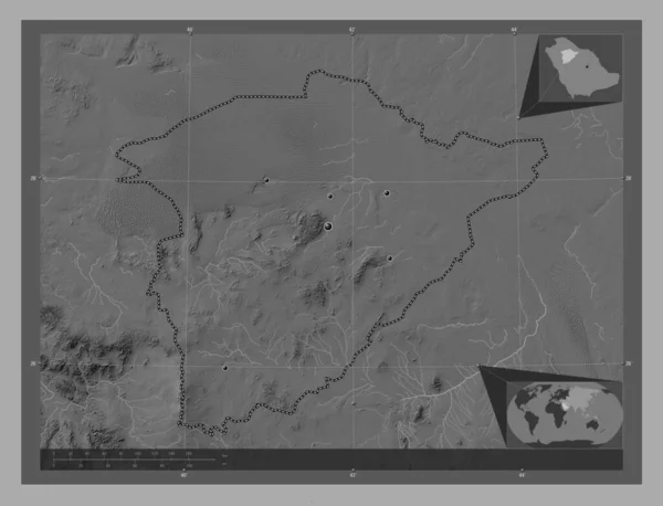
Ha'il, region of Saudi Arabia. Bilevel elevation map with lakes and rivers. Locations of major cities of the region. Corner auxiliary location maps
Esta foto
Ha'il, region of Saudi Arabia. Bilevel elevation map with lakes and rivers. Locations of major cities of the region. Corner auxiliary location maps.
Datos de la Imįgen (tiene derechos de autor*)
- Fotografķa:
Ha'il, region of Saudi Arabia. Bilevel elevation map with lakes and rivers. Locations of major cities of the region. Corner auxiliary location maps
- Autor:
- Ancho original:
4930 pķxeles.
- Altura original:
3770 pķxeles.
- Tamańo:
18.59 megapķxeles.
- Categorķas:
- Palabras Clave:
tierra Al Wajh Sau frontera contorno Arabia Saudita océano estereogrįfico geografķa Atlas Capital social Zoom: Naturaleza Tierras Duba umluj mapa Asia haql región planeta mundo Ciencia paķs división administrativa Territorio Riad Continente esquema forma Leyenda .
Popularidad
- Vistas:
- 0
- Descargas:
- 0

Fotos similares
Otros temas con fotografķas que le puede interesar
- mapa
- Ciencia
- Zoom:
- Capital social
- Riad
- Leyenda
- tierra
- haql
- estereogrįfico
- paķs
- Sau
- Atlas
- Al Wajh
- Naturaleza
- división administrativa
- Arabia Saudita
- umluj
- Asia
- esquema
- contorno
- geografķa
- mundo
- Continente
- región
- frontera
- Tierras
- Territorio
- planeta
- forma
- océano
- Duba
(*) Sitio para adquirir: Link externo para Comprar
Fotografķa de Ha'il, region of Saudi Arabia. Bilevel elevation map with lakes and rivers. Locations of major cities of the region. Corner auxiliary location maps, que incluye Ha'il, region of Saudi Arabia. Bilevel elevation map with lakes and rivers. Locations of major cities of the region. Corner auxiliary location maps.
Todas las imįgenes por Depositphotos